Soil roughness
Soil surface roughness will be measured over the fields using the 1 m long profilometer and digital camera. During SMAPVEX12, soil surface roughness will probably be modified by flattening due to rain events and by field operations. According to this, and in order to reduce damages to crops, obtain representative values of soil surface roughness at each field and optimise the number of sampling fields, the following soil roughness measurements protocol will be considered: 2 sites per field, 1 replicate of 3 m profiles per site in the look direction of each SAR sensor (RADARSAT-2 descending mode, UAVSAR, and PALS), and 2 field visits at beginning and end of the campaign. Mean roughness values will be derived from the pictures of these profiles taken with the digital camera.
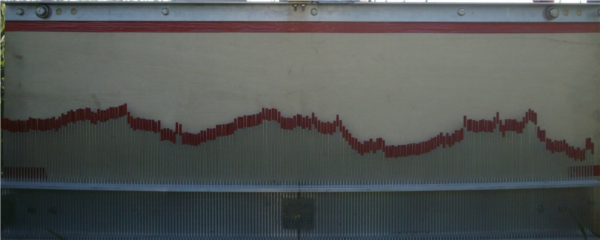
1 m long profilometer
Summary of surface roughness measurement strategy
|
Acquisitions |
| Instruments |
UAVSAR |
PALS |
RADARSAT-2 |
| Sample sites per field |
2 (same sites as PALS and RADARSAT-2) |
2 (same sites as PALS and RADARSAT-2) |
2 (same sites as PALS and RADARSAT-2) |
| Number of replicates per site |
1 |
1 |
1 |
| Number of profiles per site |
3 (placed end-to-end) |
3 (placed end-to-end) |
3 (placed end-to-end) |
| Number of field visits |
2 (at beginning and end of campaign) |
2 (at beginning and end of campaign) |
2 (at beginning and end of campaign) |